Pakistan small

Ideals Vs. Reality

TWO-MONTHS SPENT IN PURSUIT OF HIGH ALTITUDE SKIING IN PAKISTAN


Words and Images BY:
Christopher Kussmaul

This story was first published in Issue #27, buy your copy: HERE.

The Gerjerab River, Pakistan, June 10th 2022

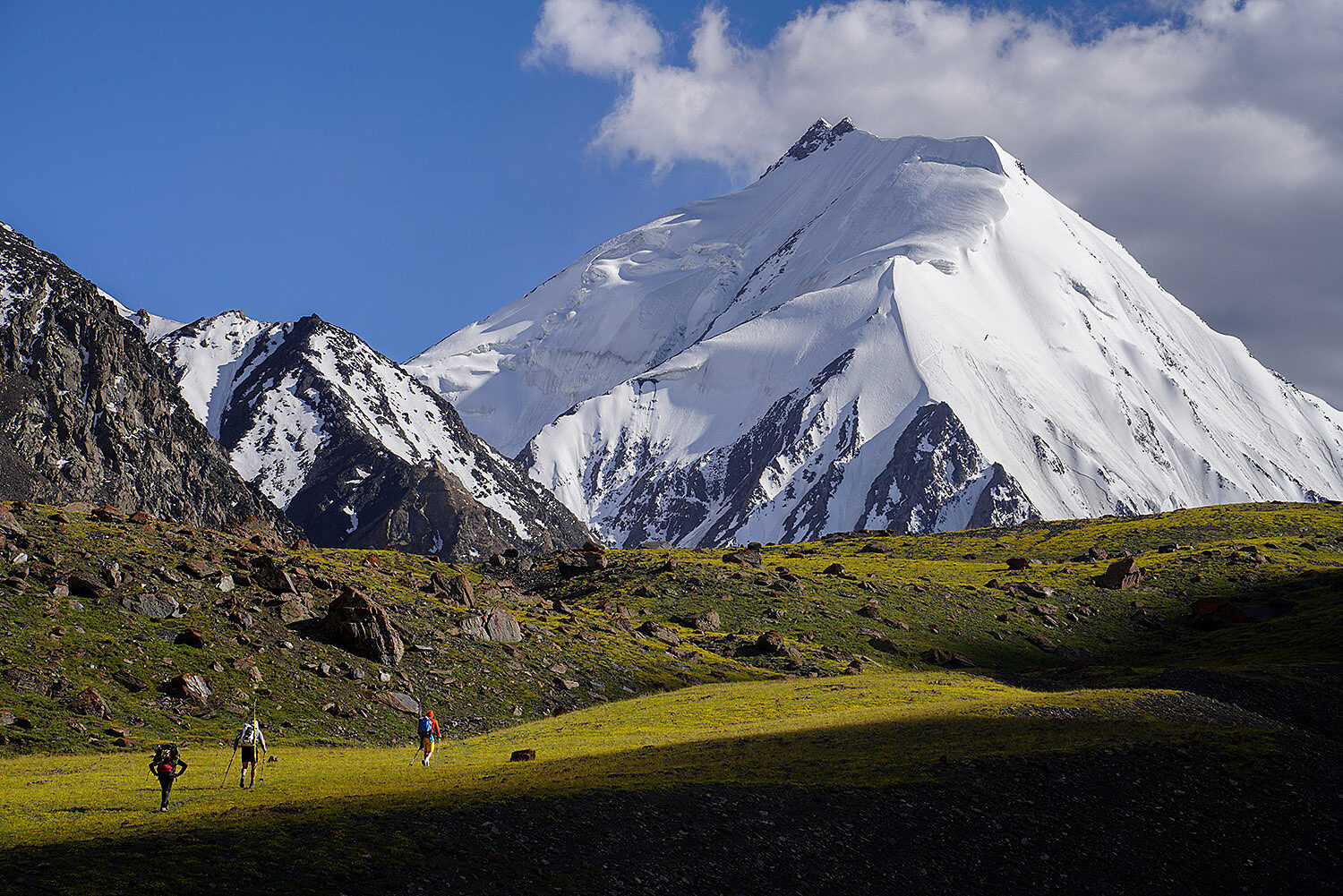
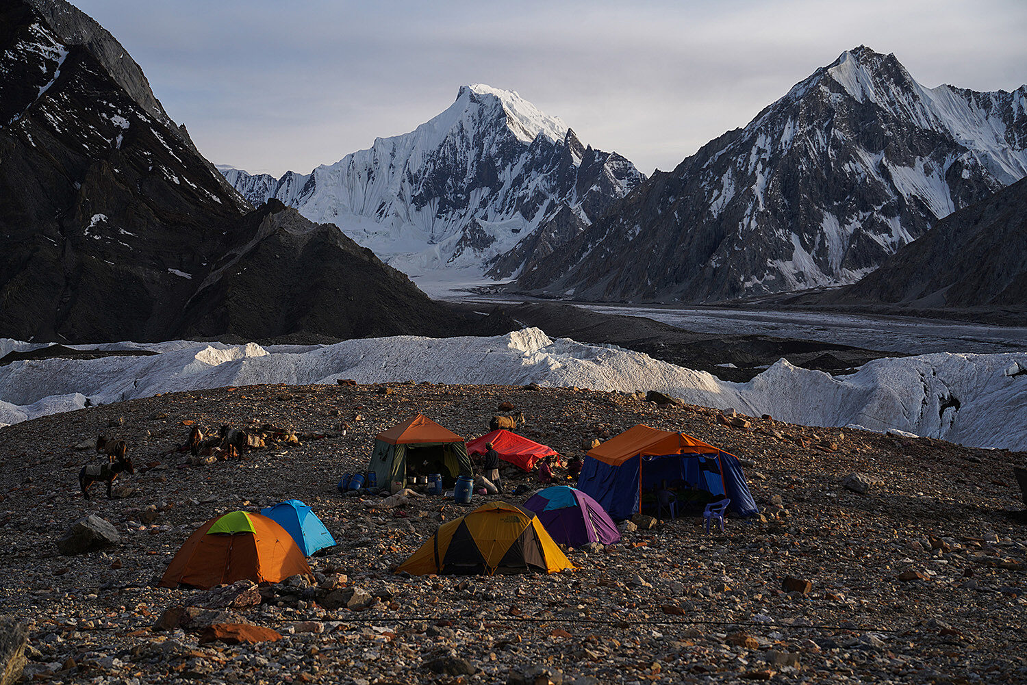
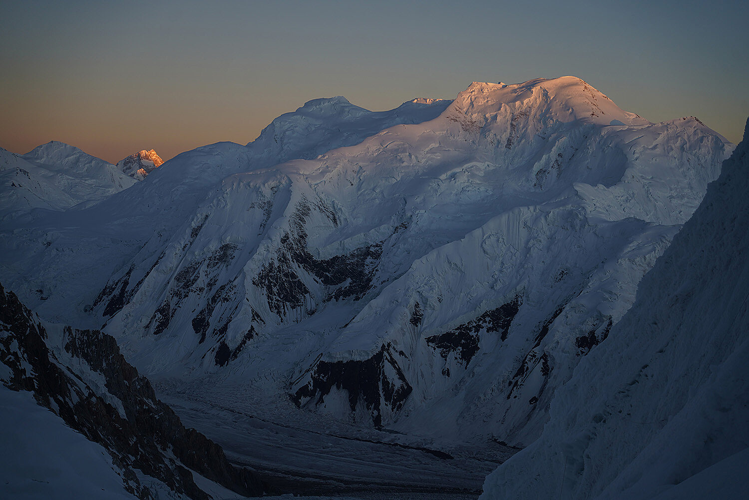
We awoke today to three inches of fresh snow and had to prod our team of 19 porters and their 19 donkeys to rally for the long day up and over Bosium Pass, down to the banks of the Gerjaurb River, whose headwaters are our destination. Along the way, we passed beautiful glaciated peaks as tiny yellow flowers competed for scant real estate in the just barely melted portions of the valley. Winter seems to have finally loosened its grip on this small slice of northern Pakistan, and the early spring weather is a welcome respite from the heat we encountered just days before further south in the country.


At the end of the day, we arrive at Mindich La, a nomadic herders’ camp comprised of nothing more than a single stone structure and a small corral made from the surrounding sea of talus. Compared to the breathtaking scenery we have passed over the past few days, Mindich La is a dry and barren place, dusty and depleted from the dozens of sheep grazing about.

The stench of urine hangs over the scene, as inescapable as the chorus of constant bleating from the flock. Stuck to the whim of our porters, we settle in for the evening. We offer to buy the team one of the sheep, a gift of sorts, as they consider the meat a great luxury that is often beyond their means. We want to celebrate the near completion of our journey to basecamp and extend every thanks we can to the porters for their companionship and the use of their donkeys over the last few days. We pretend that we know how to size up a good sheep and haggle with the herder over price, ultimately landing on what appears to be a sheep no different than any of the others for a price we have no real way to judge. Regardless, we all retire for the night with full bellies. But sleep doesn’t last long for me. I’m awoken mid-slumber by a desperate need to simultaneously vacate my bowels and the contents of my stomach. It’s a messy combo and the situation extends itself for another 36 hours of near-constant sickness. Our attempt at a feast of goodwill has left me brutally incapacitated and starting to contemplate how exactly I have found myself in this remote, nondescript corner of the Karakoram.

_______

Below Purchudvashk Return2 RESIZED

Below Purchudvashk

The origin story of this adventure began with an idea cooked up by my friend and trip companion, Matt Randall. Matt has been scheming a ski trip to Pakistan for a handful of years with the primary goal of skiing Gasherbrum II, the thirteenth tallest mountain in the world. He invited me to help organize the trip, and, after an extended period of planning/procrastinating, we finally got everything in place to make it happen this past summer. We recruited Colorado native Bill Copeland to join us as our token snowboarder, and were later joined by Salt Lake City-based crusher Jessica Shade.


In the process of planning, Matt and I decided to grow the project into a two-month effort with two distinct objectives. It wasn’t just about Gasherbrum II anymore. Having both been on previously unsuccessful ski expeditions to 8,000m peaks, we knew all too well that the possibility of success was unlikely, and we wanted to set ourselves up a bit better this time around. To that end, we planned to spend our first month focused on a relatively unexplored area at the headwaters of the Gerjerab River, a stretch of the Pakistan/China border featuring several small glaciers, a collection of 5,000 to 6,000m peaks, and the possibility for some first descents. Matt and I both have a fondness for exploratory skiing, and saw this obscure section of the range as a great opportunity to scratch that itch. We also hoped that by spending our first four weeks on the hunt above the Gerjerab, we would break ourselves in a bit and gain some long-term acclimatization that would serve us well when headed to the other side of the country to try and tackle Gasherbrum II.

The idea of setting aside an entire month to get in some authentic skiing before moving on to our primary objective also stemmed in no small part from having both witnessed the chaotic Gong show that too often characterizes the

contemporary climbing scene around 8,000m peaks. Matt and I share a strong preference for self-reliant experiences, and climbing the biggest mountains in the world is anything but self-reliant these days. In fact, climbing 8,000m peaks seems to have presently fallen out of fashion in much of the climbing community for this very reason. Many efforts on 8,000m peaks have become simple walk-ups, with their primary challenge being the ridiculous height and the paltry amount of oxygen available at their upper reaches. Fixed lines, high-altitude porters who do all the heavy lifting, and supplemental oxygen have removed the bulk of the challenges historically associated with taking on such massive mountains. However, where hardened climbers have left a void, tourists have quickly filled in. Most who set off to climb 8,000M mountains these days are wealthy professionals or Instagram celebrities with little to no climbing experience. It’s not uncommon for some to receive their first tutorials on how to use crampons when they reach basecamp. They pay guides and sherpas to carry all their belongings up the mountain, set up their tents, fix ropes, and manage their risk. Just as egregious, they also all seem to use bottled oxygen. The latter is particularly irksome to those of us who subscribe to the mountaineering ethos of “fair means,” which says that, in a sport of contrived boundaries, there need to be some basic guidelines on how we approach challenges in the alpine. And, when you consider that the typical flow rate of supplemental oxygen (two liters per minute) effectively reduces the height of the world’s highest peaks to a relatively pedestrian 10,000ft or lower, you begin to see why many members of the climbing community have grown skeptical. For us, relying on these sorts of support tactics would strip away many of the aspects of this odd and inherently risky sport that we love. Matt, Jess, Bill, and I have little appetite for the conquest of peaks by any means necessary.

Pakistan3 16

Yawash Sar Middle Top Out (left) / Matt Skiing Yawash Sar Middle (right)

With that said, our second month in Pakistan was focused on our original raison d’être; Gasherbum II and its 26,362ft summit. Guided by the standards of fair means, we aimed to do the climb without support, be it man-power or pre-packaged oxygen. Of course, we also packed our skis. I have to say that we are no ethically pure hard (wo)men. We had no designs on attempting G2 without our own set of asterisks. The goal was to climb with expeditionary tactics, meaning setting up high camps and retreating back to basecamp afterwards in hopes of slowly acclimating to the harshness of the environment. We would be moving slowly up and down the mountain over the course of a few weeks, carrying all our own gear the entire time.

Even still, we knew that we’d likely be surrounded by fixed ropes and woefully unprepared tourists, a scene that was sure to chafe against our ethics and inspirations. Ultimately, the idea of spending the first month of our trip in the lesser-known neighborhood of the Gerjerab was as much about getting ready for G2 as it was about making sure we would return home to Montana having fulfilled our own ideal of backcountry skiing.

In the end, our two-month summer “vacation” was filled with success and failure, reluctant military officials and smiling translators, ranging storms and bluebird powder, sickness and team strength, odd foods and a whole lot of hurry up and wait. What follows are some choice memories from our time in Pakistan.

_______

Ghidims Glacier, June 11–28th.

Once the violent liquid evacuation of my guts ended and I regained a bit of strength, we spent the next few days reaching the headwaters of the Gerjerab River. We set up a basecamp along its frozen shores at some 14,000ft. Afterwards, we moved up to the Ghidims Glacier to set up a smaller high camp, and immediately got to work exploring the neighborhood. Our first day up high we were treated to a cloudless day skiing Yawash Sar Middle, a previously unskied small peak whose summit has the distinction of being in both China and Pakistan. After briefly reveling in the fact that we violated Chinese sovereignty, we descended the southwest face in firm but edgeable conditions. A few turns in and it was clear that wed woken up too early for corn. Afterwards, we retreated to the valley floor and our spacious basecamp to sit out an incoming storm system. We thought it would be a day or two of forced rest, but the storm lingered for a week. We passed time playing countless games of gin rummy and drinking our rapidly dwindling supply of whiskey.

A brief break in the storm allowed for a failed attempt on Igls Peak/Ghidims Sar (it’s known by two names) before we got word of an extended period of incoming high pressure. The forecast was a breath of fresh air, as we only had four days left before the donkey caravan would return to pack our loads back to Shimshal.

The first good day of weather produced the best day of the month, and we were able to link Ghidims Sar to an unnamed and previously unclimbed/unskied peak, both over 19k.

We had taken to calling the nameless summit Cache Peak, as its beautiful west face hung over the terminus of the glacier where we had been leaving our skis whenever we descended back to basecamp. We departed high camp at 1am in hopes of being able to barrel through a cornice along its west ridge before it saw any heat, a choice that left us frozen in place in the early morning wind. Breaking trail above 19k didn’t afford much warmth, but did give us something to focus on as we struggled in the thin air. Finally, on the summit of Ghidims Sar, we found shelter from the wind in the lee of a cornice and defrosted our fingers and toes.

After a pretty subpar ski, we found ourselves back at the pass between Ghidims Sar and Cache Peak, repeating the morning’s process of breaking trail while warding off frostbite. In a blind maze of overhung cornices, tenuous belayed steps brought us to the summit along a thin line of relative safety. Matt dropped in first, and we leap-frogged down the south ridge until we could see down the proper west face. Bill set off and put both Matt and me to shame by center-punching the line with his long, arching snowboard turns. It was his mono-plank revenge for our previous insistence that, as skiers, we’d prefer steep, smooth, andfirm over deep and slightly breakable. After the angle eased up, we shed our bulky down pants and mega-puffies and rode perfect, bootcuff-deep powderdown to the toe of the glacier. We were all giddy with our day’s efforts and the impending warmth of camp. Back in the tents, the conversation shifted towards how to best use our remaining two days. We decided we’d focus on Yawash Sar II, the undisputed king of the area.

_______

Icefall4 1 RESIZED

Icefall

Yawash Sar II is immediately recognizable from anywhere in the valley, as its west face looms over the Ghidims Glacier in impressive fashion. It has a steep, broad face that slowly shrinks into a small, triangle-shaped spire at the top, a broad cliff band separating the two. Since our arrival, the face had been sparkling with grey alpine ice, visible even from camp. However, the recent week-long storm system has allowed some new, wet snow to stick to the bulletproof 55-60o ice. Since first seeing the face, a small sense of dread hung over my thoughts about the mountain and the obvious challenges its icy terrain posed. Our first attempt was predictably thwarted by a late start, coupled with the first bit of heat since we’d arrived. After bailing, we settled into camp for our last night and agreed on a 1am start for the next morning— a decision reinforced by the constant sound of wet-loose avalanches ringing throughout the valley, washing away our high point and boot pack from earlier in the day.

The next morning, in the cold of the predawn darkness, Bill decided to bail. He’d been host to a nasty cough for almost a month, and it’d taken its toll. Matt and I
decided to make the push and were soon relieved (slash terrified) to discover that yesterday’s arduous trail breaking had been replaced by a firm avalanche bed surface and runnels as deep as I am tall. The névé made for easy cramponing, and we were quickly above our previous high point. Halfway up the face, a gully-like couloir cut through the previously mentioned cliff band, an obvious access point to the summit. The terrain was steepest here, and also hosted the most ice. It seemed yesterday’s heat hadn’t washed away the snow up here, but instead reduced it to a hard, frozen slab a few inches deep. Under that were a few centimeters of massive facets directly atop the ice. We’d have to swing our picks through the snow slab before they found hold in the ice beneath, but the climbing felt relatively secure and remained light work compared to post-holing.

After the couloir, we edged our way onto the summit triangle and found that the slope angle didn’t let up, while at the same time the slab dramatically deepened. I pushed higher with one ice pick planted, using the other to smash away the now foot or more of hard slab. The danger was obvious, and I felt increasingly certain we should bail, but I struggled to find my voice. Matt interrupted my thoughts and minced no words, which were wonderful to hear: “I don’t want to summit this thing and get down feeling like we got away with anything.” Nothing more needed to be said. Only 200ft from the top, we spun in our tracks and downclimbed/rappelled the majority of the couloir before we felt as though the ice underfoot was covered enough to ski.

The day had elapsed fast, and both Matt and I had neglected to keep up on self-care, forgetting to eat and warm our increasingly numb toes. Back in the heat of high camp, I was keenly aware that I couldn’t feel anything past my toe box. Removing my boots revealed an instant anxious rush: my toes were purple, and my toenails a ghostly white. I spent nearly two hours trying to slowly warm them up, with almost zero sensation returning. As I tended to my frostbitten toes, Bill and Matt broke down our high camp. The porters would likely have already arrived at basecamp, and we needed to get down ASAP. We loaded an unnecessary number of things into our packs and headed down. My swollen toes screamed in pain as I skied out the remainder of the glacier, but at least some feeling had returned. The hike out from basecamp and back to Shimshal was a mix of bliss and heat. The previous month’s small bursts of wildflowers were being outdone by an extraordinary display of color that blanketed the entire valley floor in a wall-to-wall mosaic of spring. It was painful on my still-numb toes, but a spectacular sensation to be so hot and surrounded by such vibrant alpine greenery after a month on the snow. Along the way, we passed wolf prints in the glacial silt and the skulls of ibexes killed in avalanches, more reminders of just how far off the traveled path we had been.

_______

Igis Peak Background2 RESIZED

Igis Peak

Skardu, June 29-July1st

From the northern capital of Skardu, we said our farewells to Bill before continuing on toward G2. Simultaneously, Jess Shade, a crusher from Salt Lake City, flew in to meet us for the second half of our trip. I contemplated leaving at the behest of my toes; it had been five days since I took off my boots, and not much had improved. But Bill graciously left me his larger ski boots (he’s a hard boot snowboarder) that could accommodate an extra layer of socks, which gave me the confidence to stay.

From Skardu, we drove towards Central Karakoram
National Park and the Baltoro Glacier. The drive offered all the standard fare of a central Asia expedition approach: washed out roads that we had to help rebuild by shovel in order to keep moving, off-road scree driving, and, of course, military checkpoints with soldiers reluctant to let us pass. Given that we were now headed to an 8,000m peak, we were required by Pakistani law to have a military liaison officer accompany us. Our officer, Adnon, was a major in the Air Force and hailed from the lowland plains of Sindh. He had zero experience in the mountains. But he quickly proved his worth after a few heated phone calls in Urdu that got us through the checkpoints.

Baltoro/South Gasherbrum Glacier, July 2-31th

After some grueling hot and buggy days on the lower Baltoro, we reached the cooler climate of the upper glacier system and fell into a rhythm along the week-long trek to reach G2’s basecamp. Our destination, just past Concordia, was the intersection of some of the largest glaciers in the world, a miles-wide valley of nothing but ice and lateral moraines. It is home to four of the world’s 8,000M peaks, including the famous K2.

_______


We set up our basecamp on a moraine between the South Gasherbrum Glacier and the Baltoro Glacier, amongst a small tent city that accommodated the seven or so other expeditions vying for G2’s summit. We were relieved to find that most were small, self-sufficient groups like our own.

G2’s first main challenge is the distance that exists between basecamp and Camp One. Some five miles of icefall separate the two, and that year’s drought rendered the lower glacier a maze of cracks that had to be laboriously navigated

Hike In Camp3 1 RESIZED

Hike in Camp 3

at night via thin snow bridges. Upping the ante, the steep nature of the valley turned the broken glacier into an onslaught of hanging seracs, a constant overhead hazard that seemed unmitigated when moving so slowly through the complex terrain. Our first run-up took some nine hours. We spent the night and retreated back to the valley floor the next day.

Raging wind, snow, and rain kept us pinned at camp and in our tents for eight days. Eventually, the weather cleared, and a long period of high pressure appeared on the horizon. We carried big loads of food and fuel to camp one and hoped to get in one more acclimatization run-up to 23k before dropping down again to rest for our summit push. We carried three days of food up to Camp Two, and were met with a new and unfavorable weather update. The forecast now called for three days of perfect weather, followed by another nasty-looking storm cycle. No more run-ups or dedicated acclimatization time. Whether we liked it or not, our window had arrived.

We decided to try and stretch our light supply of food and fuel at Camp Two into four or five days’ worth. That would allow us to move slower up the mountain than previously planned in hopes of gaining some amount of acclimatization before our final push for the summit. The days passed slowly as we all struggled with the simple task of existence. Resting heart rates pushed into the 100s, and oxygen blood saturation dipped well below 70%. Even so, we eventually got situated at Camp Three in hopes of doing one long and lightweight push to the summit before our window closed. We joined up with two other teams of two, one from America and one from Germany. Both teams were also going without supplemental oxygen or other sorts of support. Our idea was to share the task of trail breaking. We departed at 11pm with confidence in the weather forecast, but without Jess, who was kept in camp by altitude sickness. At about 1am, the light breeze grew into 60mph winds, causing a torrent of spindrift that made visibility and communication impossible.

The other American team bailed first, but we kept going. An hour later, Matt and I also decided we had to turn around. The wind had gotten so absurd we could no longer stand upright. We both feared further frostbite damage to my toes, which were still healing from last month’s trip. The Germans pressed on with the only other team still going for the summit, a group of Nepali sherpas on oxygen, and their lone client and guide, also on oxygen. They moved away from us in the storm, and the thought of astronauts came to my mind as I watched the group bundled in full-down suits and oxygen masks, clipped into a steady fixed line. They looked as though they were ready to enter orbit. The contrast to our frailty was noticeable, and the idea that I’ve perhaps become too wrapped up in my own contrived set of ethics rattled loudly in my head as we turned for home. How comfortable would sea-level air be right now? How nice would it be to have the benefits of improved blood circulation?

Eventually, after turning tail, we made it back to our tent, its battered form just barely clinging to the mountainside with the weight of Jess’ body. We fell into a restless sleep, taking turns working through the night to prop the tent up in the storm. We awoke at dawn to a beautiful, windless day, and Matt and I wondered aloud: if we could’ve just withstood the wind, could we have summited with our ethics in tact? When you fail to achieve a goal that’s been stewing in your mind for so long, it’s impossible not to consider such things.

We broke camp and headed for lower ground. Our second-guessing vanished into the morning as we skied towards Camp One, enjoying the comfortable wind-buff and steep terrain. Not a single one of us had regrets as we navigated the patchwork of crevasses, our ethics still intact, and our spirits soaring across the snow.


Camp2 Sunset RESIZED

Camp 2 Sunset


SHARE THIS STORY

   
MORE FROM BOMB SNOW
Screen Shot 2021 08 02 at 3 22 12 PM
Remembering Tom Sims
J skis levinthal interview 1440 670 95
Jason Levinthal Interview
Intro letter bomb snow heath
The Heat is On
Zen art stretch final
Zen and the Art of Stretching